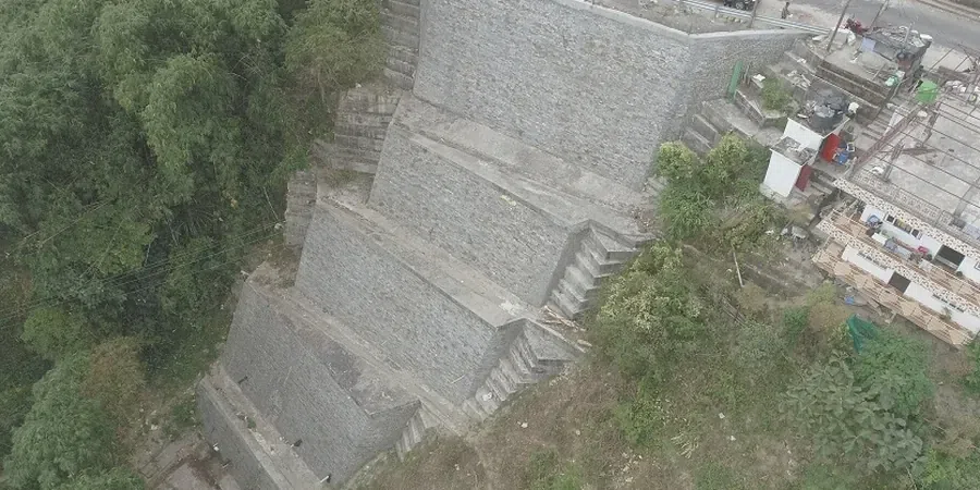
Port Macquarie sits on a complex interface of Triassic sedimentary rocks and deeply weathered coastal rhyolite, with the Hastings River cutting through steep paleo-dune formations. The 2021 heavy rainfall events triggered multiple shallow slips along Shelly Beach headland, exposing the sensitivity of local colluvial soils to pore pressure spikes. When a development cuts into a slope exceeding 4 meters in the Lighthouse Beach precinct, the residual soil profile often retains less than 15 kPa cohesion, requiring a rigorous slope stability analysis before a council DA can proceed. We combine AS 4678 design parameters with kinematic evaluation of joint sets measured directly on the face, because the local geomorphology demands a site-specific factor of safety that generic desktop studies cannot deliver.
In Port Macquarie's coastal headlands, a 2-meter rise in the perched water table can halve the factor of safety on a cut face in less than 48 hours.
Scope of work
Area-specific notes
A six-storey residential block on the escarpment above Town Beach started excavation in 2020 without a site-specific stability model. By the second week, tension cracks opened 3 meters behind the crest line, forcing a two-month stand-down while we installed inclinometers and re-ran the analysis with the true groundwater profile. The remedial design added two rows of active anchors and a shotcrete facing, but the delay cost the developer the summer construction window. Port Macquarie's warm, humid summers accelerate weathering on exposed cut faces, so we always recommend a rapid assessment cycle: map the face, install a standpipe piezometer immediately, and run the first limit-equilibrium iteration within 72 hours of excavation. Inclinometer readings over the following 30 days then validate the pore pressure assumptions before the permanent retaining structure is detailed.
Standards used
AS 4678 – Earth-retaining structures, AS 1726 – Geotechnical site investigations, AS/NZS 1170.0 & 1170.4 – Structural design actions (seismic), ASTM D4767 – Consolidated undrained triaxial compression test, Spencer (1967) limit-equilibrium method – critical non-circular slip surface
Linked services
Kinematic and Limit-Equilibrium Stability Assessment
Field mapping of discontinuity orientation, spacing, and infill material on exposed cuts in Port Macquarie. We combine stereonet analysis with Spencer-based 2D limit-equilibrium models that incorporate the perched water table measured in the field. Deliverables include a detailed geotechnical report signed by a CPEng, ready for council DA or CDC submission.
Remedial Design and Monitoring for Cut Slopes
Design of soil nail arrays, anchored shotcrete faces, and sub-horizontal drains for active slopes in the Port Macquarie coastal zone. We install inclinometers and vibrating-wire piezometers with remote data logging, providing weekly stability bulletins during the excavation phase and calibration of the original design assumptions.
Typical parameters
Top questions
What does a typical slope stability investigation cost for a residential site in Port Macquarie?
For a single-dwelling cut site in Port Macquarie with a standard 4 to 8 meter slope, the investigation and limit-equilibrium analysis typically range between AU$1,810 and AU$7,280, depending on access constraints, the number of boreholes required, and whether inclinometer monitoring is included. A fixed-fee proposal is issued after a site walkover.
How is the perched water table in the coastal dunes handled in your stability model?
We install a standpipe or vibrating-wire piezometer directly in the mid-slope bench during the drilling phase and read it daily for at least 14 days post-installation. The worst-case seasonal water level is then applied as a phreatic surface in the limit-equilibrium model, with a sensitivity run at 0.5 m above the measured level to account for prolonged wet periods.
Does council in Port Macquarie require a stability report signed by a CPEng?
Yes, Port Macquarie-Hastings Council requires a stability assessment for any cut exceeding 2 meters in height, and the geotechnical report must be signed by a Chartered Professional Engineer (CPEng) registered with Engineers Australia. Our reports include the CPEng stamp and a design certificate suitable for construction certificate (CC) lodgement.