Port Macquarie's subtropical humidity and layered coastal geology keep site investigation work honest. You can read a surface map, but the ground from Settlement Point to Thrumster hides old dune sands, estuarine silts, and deeply weathered siltstone interfaces that shift over short distances. When foundation design depends on blow counts from a Standard Penetration Test, the drill crew has to adapt to water tables barely two metres down and sands that collapse if casing is rushed. We run the SPT hammer to AS 1726, measuring N-values every 1.5 metres, while the field van carries calibrated gear for Atterberg limits and grain size classification from the same borehole. The split-spoon sampler tells a story that desktop geology cannot.
When refusal hits at less than three metres on phyllite, the N-value alone justifies a shallow bearing design—saving weeks on piling.
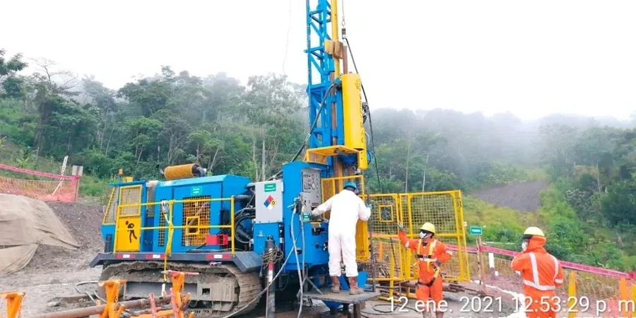
Scope of work
Area-specific notes
The mid-north coast isn't the highest seismic zone in Australia, but the AS/NZS 1170.4 hazard map assigns Port Macquarie a hazard factor that requires liquefaction screening in loose saturated sands—exactly the material found beneath canal-side subdivisions and reclaimed waterfront parcels. A borehole log showing N-values below 10 blows in clean sand between 1.5 and 5 metres depth raises an immediate flag. The standard penetration test provides the raw N60 data for the Seed-Idriss simplified procedure, and our lab reports include fines content from companion grain size tests so the geotechnical engineer can correct cyclic resistance ratios without guesswork. On the escarpment slopes behind Lighthouse Beach, residual clay over weathered phyllite creates a different risk: a stiff crust that masks softer zones, where SPT refusal may come after only a few blows, misleading the driller into thinking competent rock has been reached when the sampler is actually wedged in a boulder.
Standards used
AS 1726-2017 Geotechnical site investigations, AS 4678-2002 Earth-retaining structures, AS/NZS 1170.4:2007 Structural design actions – Earthquake actions, ASTM D1586-18 (referenced for SPT energy calibration), Seed & Idriss (1985) – liquefaction assessment framework
Linked services
On-site SPT drilling and logging
Track-mounted and portable rigs for tight access. Full AS 1726 logs with N-values, soil descriptions, groundwater observations, and refusal notes. We cover the Hastings, Camden Haven, and Wauchope hinterland.
Companion laboratory classification
Moisture content, Atterberg limits, particle size distribution, and fines content on every disturbed sample. Results are cross-referenced with the field log within 48 hours so the design team has a complete data set.
Liquefaction screening packages
N60 correction, fines content, and depth-to-water-table data compiled into a single report for the geotechnical engineer to run Seed-Idriss analysis. We flag boreholes where further CPT or shear-wave velocity testing is warranted.
Typical parameters
Top questions
How much does an SPT borehole cost in Port Macquarie?
A single borehole with Standard Penetration Testing typically ranges from AU$720 to AU$1,120, depending on depth, access conditions, and whether we need to core through rock. A two-borehole package for a residential site in Port Macquarie usually falls between AU$1,400 and AU$2,200, including logs and basic lab classification.
How deep do you drill for a standard house site in the Hastings area?
Most residential investigations in Port Macquarie run between 6 and 12 metres, or until refusal on phyllite bedrock. If the site is on a cut-and-fill terrace, we extend at least 3 metres into natural ground below the fill line to capture bearing strata.
What’s the difference between SPT and CPT in Port Macquarie’s coastal sands?
SPT recovers a physical sample you can see and test in the lab; CPT gives a continuous profile of tip resistance and pore pressure but no sample. In the canal estates and dune corridors, we often run SPT first for classification and follow up with CPT where liquefaction risk needs a finer depth resolution.
Do you hit refusal often in Port Macquarie?
Yes, especially on the southern and western slopes where weathered phyllite lies shallow. Refusal—50 blows over any 150 mm increment—is common between 2 and 5 metres. When that happens, we switch to coring to confirm rock quality for foundation design.
How soon do I receive the borehole logs after drilling?
Field logs are available within 24 hours. The final signed report with lab results and N60 corrections is typically delivered in three to five working days. We can fast-track to 48 hours for urgent projects where the excavator is already booked.