A four-storey apartment block on the edge of the Hastings floodplain stalled at DA stage because council flagged a Class C assumption under AS 1170.4. The developer assumed it was rock because they hit sandstone at three metres. We ran a 69-metre MASW spread along the western boundary and mapped the transition from loose estuarine silts into the Port Macquarie bedrock interface, which here undulates sharply due to paleochannel incision. The Vs30 came back at 298 m/s, solidly Class C, and the structural engineer could then use the design response spectrum that actually matched the site rather than the default envelope. Where the coastal terrace gravels wedge against weathered Triassic metasediments, direct shear-wave velocity profiling becomes essential. We often pair the survey with a CPT test to check for soft lenses within the upper 10 metres, and with seismic refraction when the site straddles a suspected paleochannel, giving us a continuous stiffness model down to refusal depth.
A Vs30 value derived from active-source MASW gives the structural engineer a site-specific design spectrum instead of the generic AS 1170.4 envelope, often saving tens of thousands in structural overdesign.
Scope of work
Area-specific notes
The mistake we see repeatedly in Port Macquarie is assuming that shallow refusal on sandstone equates to Class B. A structural firm designed a medical centre near the hospital on the basis of two boreholes that terminated at 4 metres in weathered metasediment; the Vs30 measurement we performed afterwards showed the upper 30 metres averaged only 420 m/s, placing it firmly in Class C, because the weathering profile extends far deeper than the auger refusal suggests. Class underestimation leads to spectral accelerations that are 30–40% too low, which directly compromises the lateral load system. The other common error is ignoring the soft clay layers trapped between sand ridges in the estuarine depositional environment; these layers reduce the time-averaged velocity disproportionately and can push a site from Class C to Class D. Without a direct Vs profile, the designer is guessing, and the consequence is either an unsafe structure or a costly retrospective upgrade during construction.
Standards used
AS 1726:2017 — Geotechnical site investigations, AS 1170.4:2007 (R2018) — Structural design actions: Earthquake actions in Australia, AS 4678:2002 — Earth-retaining structures, NEHRP provisions for site classification (complementary reference)
Linked services
MASW 1D profiling
Single-array survey for Vs30 determination on residential and low-rise commercial lots. Report includes site class to AS 1170.4, time-averaged velocity logs, and a design response spectrum envelope.
2D MASW cross-sections
Multiple overlapping arrays along a transect to map lateral velocity variations across the site. Used where paleochannels, buried gravel bars, or variable weathering profiles are suspected.
MASW with microtremor H/V
Passive-source complement when depth to engineering bedrock exceeds 50 metres. The combined active-passive approach extends the resolvable depth to 100+ metres for deep basin sites.
Seismic site class audit
Independent verification of site class for existing structures where the original geotechnical report lacks Vs data. Frequently requested by structural engineers during building upgrade assessments.
Typical parameters
Top questions
What does a MASW survey cost for a residential block in Port Macquarie?
A standard MASW survey for a single dwelling block runs from AU$2,760 to AU$4,500 including the filed acquisition, data processing, inversion, and the geotechnical report with the AS 1170.4 site classification. The price varies with the array length required — if the block is narrow or steep and we need to split the line, the logistics add a bit of time, but we quote firmly before mobilising.
How long does the field work take and what access do you need?
The crew needs about an hour on site: 25 minutes to lay the geophone line, 10 minutes to shoot the record, and the rest to pack up. We need a roughly level strip of ground 50 to 70 metres long, clear of thick bush. On the sloping blocks common around Port Macquarie’s escarpment, we can work with shorter segments and still get a reliable Vs30 by combining the data.
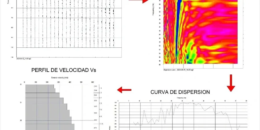
What is the difference between MASW and seismic refraction?
MASW uses surface-wave dispersion to map shear-wave velocity, which relates directly to soil stiffness and site class. Seismic refraction maps P-wave velocity and gives a layered model of the compressional-wave velocity structure. For AS 1170.4 site classification, MASW is the direct measurement because site class depends on Vs (shear-wave velocity), not Vp. We run both when the client also needs rippability or depth-to-bedrock information for excavation planning.
Does council accept MASW for the site classification report?
Yes. Port Macquarie-Hastings Council accepts MASW with Vs30 reporting under AS 1726:2017 and AS 1170.4. We provide a full report signed by our geotechnical engineer that includes the raw field records, the dispersion curve, the inverted Vs profile, and the site class assignment. It meets the same evidentiary standard as downhole seismic or cross-hole testing for the purpose of the DA submission.