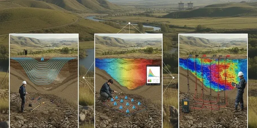
AS 1726:2017 sets the benchmark for geotechnical site investigations across Australia, and in coastal NSW, the ability to resolve complex subsurface geometries is what separates a straightforward project from one plagued by unforeseen ground conditions. Port Macquarie sits at the mouth of the Hastings River, where deep paleochannels carved into the underlying Carboniferous metasediments are masked by estuarine clays and recent alluvial deposits. Seismic tomography, employing both refraction and reflection processing on a single spread, maps these hidden channels and the top-of-rock profile with a resolution that conventional drilling alone cannot achieve economically. For developers working near the Port Macquarie coastal plain or the rolling terrain west of the Pacific Highway, integrating a MASW survey with tomographic lines delivers a continuous Vs profile that feeds directly into site class determination per AS 1170.4, while a resistivity survey can help discriminate between dry sand lenses and water-filled gravels that show similar seismic velocities.
Tomographic velocity models resolve paleochannel boundaries that isolated boreholes miss, reducing pile length uncertainty across Port Macquarie's alluvial floodplain.
Scope of work
Area-specific notes
One observation from years of reviewing Port Macquarie geotechnical data is that the Hastings River paleochannels do not run where surface topography suggests, and assuming a flat bedrock profile beneath a level paddock has led to costly bulk earthworks claims on more than one subdivision. Skipping a tomographic survey in favour of a sparse drilling pattern introduces a real risk of misinterpreting buried channel geometry, which cascades into incorrect cut-fill balance, unexpected groundwater inflows during bulk excavation, and pile tip elevations that miss the specified bearing stratum. In the shale and greywacke units common west of the Oxley Highway, seismic refraction also flags zones of deeply weathered, soil-like rock that behave as excavation material but present as rock on the driller’s log, something a velocity tomogram clarifies by mapping the 1200 m/s and 2000 m/s boundaries that correlate with rippable and non-rippable material.
Standards used
AS 1726:2017 – Geotechnical site investigations, AS 1170.4:2007 (R2018) – Earthquake actions in Australia, ASTM D5777-18 – Standard guide for using the seismic refraction method, AS 4678:2002 – Earth-retaining structures (seismic earth pressure coefficients), NEHRP site classification (Vs30 correlation)
Linked services
Refraction micro-tomography for rippability
High-resolution 2 m geophone spacing on short spreads (46–69 m) to map the weathered rock boundary for earthworks contractors, with velocity-based rippability classification correlated to excavator and rock breaker performance on Port Macquarie metasediments.
Combined refraction/reflection for deep targets
Longer spreads with 5 m spacing and higher-energy source for projects requiring bedrock profiling beyond 30 m depth, such as bridge piers in the Hastings River floodplain or deep sewer alignments through paleochannel sequences.
Vs30 and site class determination
MASW or refraction-derived shear-wave velocity profiles processed to compute Vs30 for AS 1170.4 site classification, integrated with seismic tomography to provide lateral continuity of the site class boundaries across the development footprint.
Cross-hole and downhole seismic tomography
Borehole-to-borehole or surface-to-borehole tomographic imaging for critical infrastructure where the highest resolution is required between existing drillholes, used on hospital and school projects in the Port Macquarie region where soil-structure interaction demands precise dynamic moduli.
Typical parameters
Top questions
When is seismic tomography preferred over just drilling more boreholes?
Seismic tomography fills the gap between boreholes with continuous velocity data, which is especially valuable in Port Macquarie where paleochannels and variable weathering create lateral changes that even a tight grid of boreholes can miss. It is often more economical than doubling the borehole count and provides P-wave velocity models that feed directly into rippability assessments and seismic site class determination for AS 1170.4 compliance.
Can seismic refraction work in urban Port Macquarie with traffic and pavement noise?
Yes, although the signal-to-noise ratio requires careful management. We use a high-stacking fold and an accelerated weight drop source that generates a repeatable signal above typical urban ambient noise. Surveys along road reserves or in commercial areas are scheduled during lower-traffic windows, and the processing workflow includes frequency filtering and first-break muting designed to suppress cultural noise while preserving the refraction arrivals.
What is the typical cost range for a seismic tomography survey in Port Macquarie?
For a single 115-metre refraction spread with 24 geophones, processed to a 2D velocity tomogram with geological interpretation, the cost typically falls between AU$4,230 and AU$9,180 depending on site access, terrain, and whether reflection processing is added. Multi-line surveys for subdivisions or infrastructure corridors are quoted per lineal metre with volume discounts applied.
How do you calibrate seismic velocities to actual rock strength?
The velocity tomogram is calibrated against at least one borehole or test pit logged to AS 1726 standards. P-wave velocity boundaries at 1200 m/s and 2000 m/s are empirically correlated with rippable and marginal-to-non-rippable material in Port Macquarie's metasedimentary rocks, and where dynamic moduli are required for foundation design, we run cross-hole or downhole surveys to measure shear-wave velocity directly and compute small-strain stiffness parameters.
Does seismic tomography work for detecting cavities or old mine workings?
Refraction tomography alone has limited sensitivity to air-filled voids because refracted rays travel around low-velocity zones, but combined with reflection processing we can image void-related impedance contrasts when the cavity is large relative to the seismic wavelength. In Port Macquarie, where historical sand extraction pits exist in some areas, we often pair seismic tomography with electrical resistivity profiling to cross-validate anomalies before committing to intrusive investigation.