Port Macquarie sits at the mouth of the Hastings River, where Quaternary alluvium and estuarine clays can hide old paleochannels and saline wedges at depth. With a population pushing past 50,000 and new subdivisions climbing the coastal slopes behind Settlement Point, guessing what lies beneath the topsoil gets expensive fast. Electrical resistivity testing—specifically Vertical Electrical Sounding (VES)—lets us see the layering without turning a sod. By injecting current and measuring the potential difference, we map contrasts between sands, clays, and weathered bedrock down to 40 metres or more. That matters when you need to know depth to rock for piling, or whether groundwater salinity will attack concrete, before the excavator arrives. For deeper bedrock profiling, we often pair resistivity with seismic refraction to cross-check the velocity model against the resistivity section.
Wenner and Schlumberger arrays let us map fresh-to-saline groundwater boundaries without a single borehole—critical in Port Macquarie's coastal aquifers.
Scope of work
Area-specific notes
Port Macquarie's growth through the 1990s and 2000s pushed residential development onto former estuarine flats and low-lying coastal sands where saline groundwater sits less than two metres below the surface. Skip a resistivity survey here, and you can end up with sulphate attack on concrete footings or steel piles corroding well before their design life. We have also seen undetected paleochannels beneath proposed detention basins—sand-filled former river channels that daylight during excavation and blow the dewatering budget. A few well-placed VES soundings, tied to even one control borehole, reduce those surprises to a manageable line item. The survey itself is non-invasive, so you don't trigger erosion controls or disturb acid sulfate soils, which is a constant concern along the Hastings floodplain.
Standards used
AS 1726 – Geotechnical site investigations, AS/NZS 1170.0 – Structural design actions (general principles), ASTM D6431 – Standard guide for using the DC resistivity method for subsurface investigation
Linked services
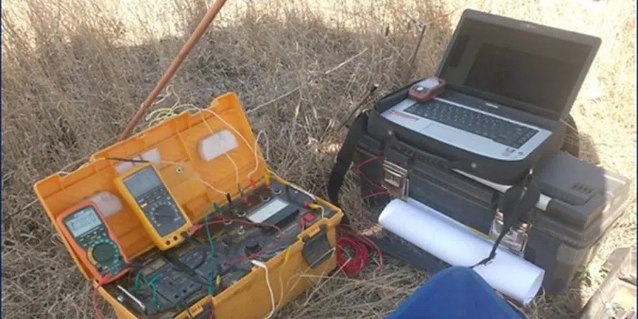
1D Vertical Electrical Sounding (VES)
A single-point sounding that produces a resistivity-versus-depth curve at a specific location. Ideal for estimating depth to bedrock beneath a proposed pad, mapping the fresh-salt groundwater interface near the coast, or siting a water bore. We run Schlumberger arrays with expanding current electrodes and interpret the curve against local borehole logs where available.
2D Resistivity Imaging (ERT)
A multi-electrode traverse that builds a continuous cross-section of subsurface resistivity. Useful for tracing paleochannels, detecting seepage paths through embankment levees, or profiling the thickness of coastal sand deposits. The 2D section often reveals lateral changes that a single VES sounding can miss, and we deliver the inversion model as a colour contour section ready for your design consultant.
Typical parameters
Top questions
What ground conditions in Port Macquarie suit a resistivity survey best?
Resistivity works particularly well where there is a strong electrical contrast between layers—think dry sands over saturated clays, or fresh bedrock beneath conductive estuarine sediments. Along the Hastings River and the coastal plain, we often use VES to find the base of the alluvium or to map the freshwater-to-saline-water transition in the shallow aquifer. It is less effective where both overburden and bedrock are highly resistive, such as dry sandstone over dry granite, but that is uncommon in Port Macquarie's coastal geology.
How much does a resistivity survey cost in Port Macquarie?
A single VES sounding typically runs between AU$870 and AU$1,640, depending on the maximum depth of investigation and the electrode spread required. A 2D resistivity line with multiple electrodes and a longer traverse will sit toward the upper end or slightly beyond, especially if the site access is tight and requires extra labour. We provide a firm quote after reviewing your site plan and objectives.
Can resistivity tell me the depth to rock for piling design?
Yes, it is one of the most common applications we run around Port Macquarie. The resistivity contrast between soil and bedrock is usually strong enough to pick the interface within about 10 percent of the true depth, provided we have at least one control point such as a borehole or outcrop nearby. For critical piling, we recommend pairing the resistivity line with a CPT test or a borehole to calibrate the geophysical interpretation.
Will the survey damage my site or disturb the ground?
No. The electrode stakes are thin stainless-steel pins pushed in by hand to about 200 mm depth, and we remove them immediately after the reading. There is no drilling, no excavation, and no vibration. On soft ground we use a small amount of salt water around each stake to improve contact, but that washes away with the next rain. It is one of the few investigation methods accepted in Port Macquarie's acid sulfate soil management areas without triggering a disturbance permit.